
Land cover classification of the Kuibyshev reservoir islands using multispectral remote sensing data
Keywords:
islands, Kuibyshev reservoir, land cover, remote sensing, classificationAbstract
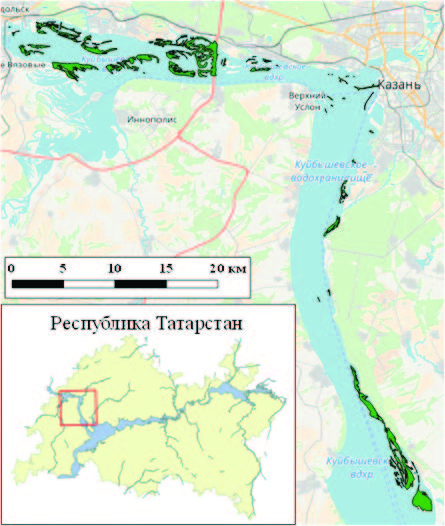
The land cover of islands of the Kuibyshev reservoir on location of the Kazan region of the variable affluent was classified. Spectral layers of the Landsat 8 OLI image, as well as 22 spectral indices, were used for classification. On the territory of island systems, 5 main types of land cover (woody vegetation, grass vegetation, bare soil, sand, flooded soil, urbanized territories) were identified and the area occupied by them was estimated.
References
Иванов Д.В., Григорьян Б.Р., Бойко В.А., Баршева К.В., Марасов А.А. О правовом статусе островов водохранилищ Российской Федерации // Экологическое право. 2007. №3. С. 33–38.
Изменения уровней водохранилищ ГЭС РусГидро, 2018. [Электронный ресурс]. Режим доступа: http://www.rushydro.ru/hydrology/informer. (Проверено: 17.10.2018).
Рязанов С.С., Сахабиев И.А., Галимов Д.З. Классификация земного покрова островов Куйбышевского водохранилища с использованием данных дистанционного зондирования // Российский журнал прикладной экологии. 2015. №3. С. 50–55.
Banko G. A review of assessing the accuracy of classifications of remotely sensed data and of methods including remote sensing data in forest inventory. Luxemburg : International Institute for Applied Systems Analysis, 1998. 42 p.
Barati S., Rayegani B., Saati M., Sharifi A., Nasri M. Comparison the accuracies of different spectral indices for estimation of vegetation cover fraction in sparse vegetated areas // The Egyptian Journal of Remote Sensing and Space Science. 2011. V. 14, I. 1. P. 49–56.
Boegh E., Soegaard H., Broge N., Hasager C., Jensen N., Schelde K., Thomsen A. bAirborne Multi-spectral Data for Quantifying Leaf Area Index, Nitrogen Concentration and Photosynthetic Efficiency in Agriculture // Remote Sensing of Environment. 2002. V. 81. №2–3. P. 179–193.
Chavez P.S. Image-Based Atmospheric Corrections ‒ Revisited and Improved Photogrammetric Engineering and Remote Sensing // American Society of Photogrammetry. 1996. №62. P. 1025–1036.
Congedo L., Munafò M., Macchi S. Investigating the relationship between land cover and vulnerability to climate change in Dar es Salaam. Working Paper. Rome: Sapienza University, 2013. 58 p.
Deng Y., Wu C., Li M., Chen R. RNDSI: A ratio normalized difference soil index for remote sensing of urban/suburban environments // International Journal of Applied Earth Observation and Geoinformation. 2015. №39. P. 40–48.
Drury S. Image Interpretation in Geology. London: Allen and Unwin, 1987. 243 p.
Huete A., Didan K., Miura T., Rodrigez E., Gao X., Ferreira L. Overview of the Radiometric and Biophysical Performance of the MODIS Vegetation Indices // Remote Sensing of Environment. 2002. №83. P. 195–213.
Huete A. A soil adjusted vegetation index SAVI // Remote Sensing of Environment. 1988. №25. P. 295–309.
James G., Witten D., Hastie T., Tibshirani R. An introduction to Statistical Learning with Applications in R. London, Springer New York Heidelberg Dordrecht, 2013. 440 p.
Kauth R., Thomas G. The Tasselled Cap – A Graphic Description of the Spectral-Temporal Development of Agricultural Crops as Seen by LANDSAT. LARS Symposia, 1976. Paper 159. P. 41–51.
Landsat 8 (L8) data users handbook. South Dakota: EROS. Sioux Falls, 2015. 106 p.
Liaw A., Wiener M. Classification and Regression by randomForest. RNews. 2002. V. 2/3. P. 18–22.
Lopez G., Caselles V. Mapping Burns and Natural Reforestation using Thematic Mapper Data // Geocarto International. 1991. № 6. P. 31–37.
Louhaichi M., Borman M., Johnson D. Spatially Located Platform and Aerial Photography for Documentation of Grazing Impacts on Wheat // Geocarto International. 2001. № 1. P. 65–70.
QGIS Development Team. QGIS Geographic Information System. Open Source Geospatial Foundation, 2018. [Электронный ресурс]. Режим доступа: http://qgis.osgeo.org (проверено: 11.10.2018).
Qi J., Chehbouni A., Huete A., Kerr Y., Sorooshian S. A modified soil adjusted vegetation index (MSAVI) // Remote Sensing of Environment. 1994. №48. P. 119–126.
R Core Team. R: A Language and Environment for Statistical Computing. R Foundation for Statistical Computing, Vienna, Austria, 2018. [Электронный ресурс]. Режим доступа: http://www.R-project.org. (Проверено: 11.10.2018).
Rouse J., Haas R., Schell J., Deering D. Monitoring vegetation systems in the Great Plains with ERTS. Third ERTS Symposium. NASA, 1973. P. 309–317.
Sripada R., Heiniger R., White J., Mejer A. Aerial Color Infrared Photography for Determining Early In-season Nitrogen Requirements in Corn // Agronomy Journal. 2006. № 98. P. 968–977.
Sripada R. Determining In-Season Nitrogen Requirements for Corn Using Aerial Color-Infrared Photography // Ph.D. dissertation, North Carolina State University, 2005. 262 p.
Yang Z., Willis P., Mueller R. Impact of Band-Ratio Enhanced AWIFS Image to Crop Classification Accuracy // Proceedings of the Pecora 17 Remote Sensing Symposium, Denver, 2008. 11 p.
Downloads
Published
How to Cite
Issue
Section
License

This work is licensed under a Creative Commons Attribution-NonCommercial 4.0 International License.


